13:50 The Global Ecosystem Dynamics Investigation (GEDI) Lidar
Dubayah, Ralph University of Maryland, United States of America
Show abstract
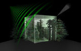
Spaceborne lidar has been identified as a key technology by the international ecosystem science community because it enables accurate estimates of canopy structure and biomass and forms the basis for fusion approaches that extend the capabilities of existing and planned radar missions, such as the NASA-ISRO SAR and the ESA BIOMASS mission. The Global Ecosystems Dynamics Investigation Lidar (GEDI Lidar) was recently selected by NASA's Earth Ventures Instrument (EVI) program. From its vantage point on International Space Station, GEDI Lidar provides high-resolution observations of forest vertical structure and addresses three, core science questions: What is the aboveground carbon balance of the land surface? What role will the land surface play in mitigating atmospheric CO2 in the coming decades? How does ecosystem structure affect habitat quality and biodiversity? GEDI informs these science questions by making 16 billion lidar waveform observations per year. The instrument uses three laser transmitters to produce 14 parallel tracks of 25 m footprints. These canopy measurements are then used to measure biomass, and in fusion with radar and other remote sensing data, to quantify changes in biomass resulting from disturbance and recovery. GEDI further marries ecosystem structure from lidar with ecosystem modeling to predict the sequestration potential of existing forests and to evaluate the impact of policy-driven afforestation and reforestation actions on sequestering additional carbon. Lastly, GEDI’s observations of ecosystem structure provide a mapping of critical habitat metrics at the fine scales required for understanding the patterns, processes, and controls on biodiversity and habitat quality. The selection of GEDI Lidar, when combined with the rapid advancement of new radar missions and the availability of long-term land cover archives from passive optical sensors, ushers in an exciting new era of land surface imaging with far ranging consequences for ecosystem science.
13:30 Global forest observation using the L-band SARs on ALOS and ALOS-2
Shimada, Masanobu; Watanabe, M.; Motooka, T. Japan Aerospace Exploration Agency JAXA, Japan
Show abstract
The globe is being suffered from the expanded human activities and the resultant global warming becomes the biggest issue that human cannot avoid. Forest is one of the main drivers that causes the terrestrial carbon change and has to be observed and monitored from the space for a long time. As a sensor to monitor such an earth, the spaceborne L-band SARs becomes to increase the importance significantly because of their all weather observation capability and the significant sensitivity on the forest status. During the earth observation history of the Japan Aerospace Exploration Agency (JAXA), three generation SARs all in L-band frequency have been made available. They are JERS-1 (1992-1998), ALOS/PALSAR (2006-2011), and ALOS-2/PALSAR-2 (2014~), all of which were supported by the digital recording capability for monitoring the earth. The first two were operated for 12 years in total and collected over 2.5 million scenes (40 million JERS-1/SAR scenes and 2.1 million ALOS/PALSAR scenes) of the earth surfaces, which also corresponds to more than 30 time coverage’s of the Earth surfaces. These data were processed at the end and provided the historical Earth faces in 1990s and 2000s at the L-band, i.e., 23 cm of the wavelength. The enhanced processing facility made ALOS/PALSAR available for the global researchers with the 25-meter resolution ortho-rectified SAR map over 2007, 2008, 2009, and 2010. L-band SAR backscatter provides the core part of the forest information, i.e., forest, non-forest in the global scale and the enhanced land use classes. The next successor to the ALOS/PALSAR is the new borne spaceborne ALOS-2, which was launched on May 24 2014 carrying the PALSAR-2, the enhanced version of the PALSAR. It has multiple resolutions of the 3m-6m-10m, the multi polarization, and the three typical operation modes, strip-spotlight and ScanSAR modes. It is right in the middle of the initial calibration and mission check phase. ALOS-2/PALSAR-2 is already implement to global observation system using the L-band SAR. In this presentation, we will show the current status of the ALOS-2, performance capability on forest monitoring, and the forest monitoring results done by PALSAR and scenario using the ALOS-2/PALSAR-2.
 In May 2013, the Biomass mission concept was selected to become the next in the series of satellites developed to further our understanding of Earth.
 REPLAY EARTH EXPLORER 7 USER CONSULTATION MEETING (PART 1)
 POLinSAR 2013 Workshop